Authors:
(1) Scott Conn, California Institute of Technology, Pasadena, California;
(2) Joseph Fitzgerald, California Institute of Technology, Pasadena, California;
(3) Jorn Callies, California Institute of Technology, Pasadena, California.
Table of Links
2. Observations
a. NIW Data
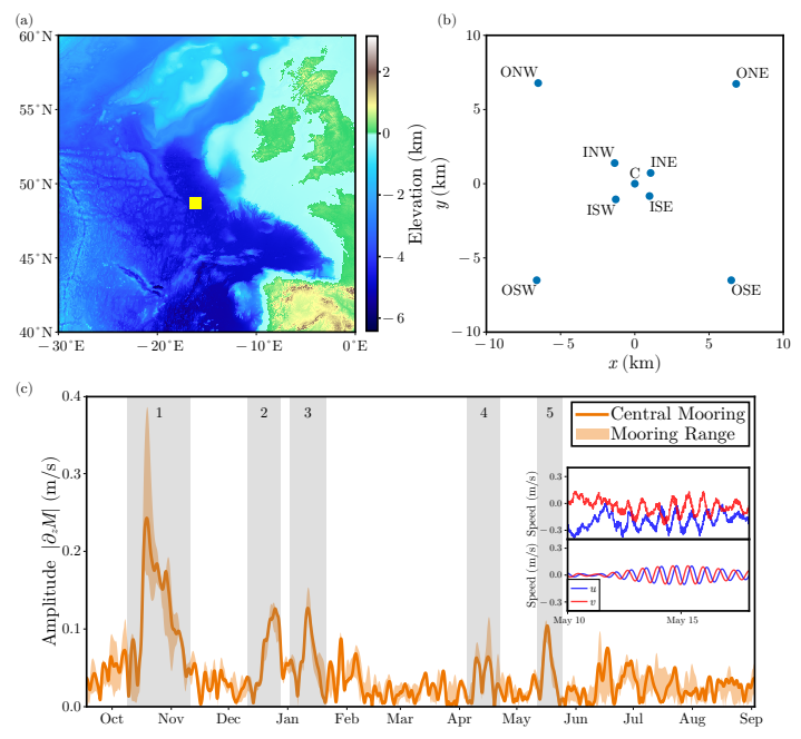
We extract observations of NIWs from data collected for the Ocean Surface Mixing, Ocean Submesoscale Interaction Study (OSMOSIS; Buckingham et al. 2016). As part of the study, measurements were taken from nine moorings anchored over the Porcupine Abyssal Plain in the northeastern part of the Atlantic Ocean from September 2012 to September 2013. The moorings were all distributed less than 10 km from a central mooring located at (48.6875◦N, −16.1875◦E) (Fig. 1a,b).
In this study, we focus on observations from the central mooring and the four outermost moorings. Each mooring took measurements of the horizontal velocity once every ten minutes using an acoustic current meter (ACM). On the central mooring, there were 13 ACMs spaced nominally between 50 m and 500 m depth. On the outer moorings there were five ACMs nominally spaced over the same depth range. The deepest ACM failed on the outer northeast (ONE) mooring, and so measurements are only available to a depth of 361 m.

The actual depth of the instruments varied in time due to drag exerted by the flow on the moorings. Over the course of the year, there were several times where the moorings experienced knockdown by up to 200 m (Callies et al. 2020). We flag these events if the knockdown on the central mooring is more than 10 m when averaged with a 1-day running mean.
Outside of these knockdown events the variations in mooring depth about the nominal depth is ∼2 m. The interpretation of the observed NIW signal during these knockdown events is complicated because the filter we use to extract the NIW signal does not commute with evaluating the signal along the trajectory of the ACMs. We do not attempt to explain the observations during the knockdown periods.

b. Stratification and mixed layer Depth

c. Wind Data

d. Altimetry
To characterize the mesoscale eddy field, we use observations of the sea surface height (SSH) from the Data Unification and Altimeter Combination System’s (DUACS) delayed-time (DT) 2018 release (Taburet et al. 2019). The DUACS DT2018 SSH maps are provided at a nominal (1/4) ◦ and daily resolution. We convert these measurements to a geostrophic streamfunction using 𝜓 = 𝑔ℎ/ 𝑓 , where ℎ is the SSH and 𝑓 is the latitude-dependent Coriolis parameter.
This paper is available on arxiv under CC 4.0 license.

